A Normal Flight That Never Reached Its Destination
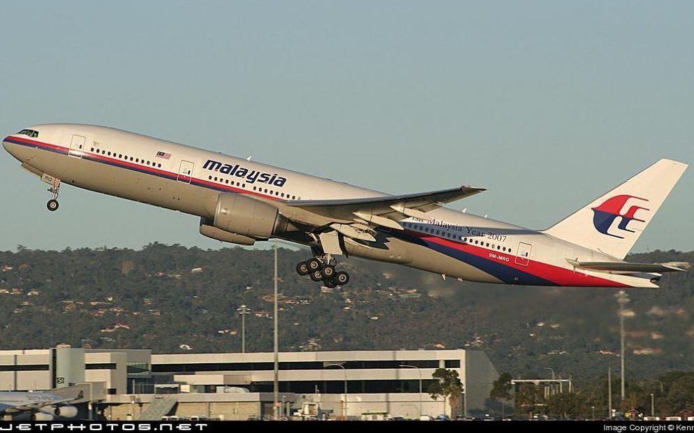
On the night of 7 March 2014, Malaysia Airlines Flight MH370 was preparing to leave Kuala Lumpur International Airport for Beijing. It was a normal scheduled passenger flight operated by a Boeing 777-200ER registered as 9M-MRO. There were 227 passengers and 12 crew members on board, making a total of 239 people.
Among them was someone very dear to a very good Malaysian friend of mine. Therefore, whenever I read or write about MH370, I cannot look at it only as an aircraft accident investigator or an aviation person. Behind the aircraft registration, radar information, satellite signals and underwater searches were 239 people who had families and friends waiting for them to arrive.
The aircraft pushed back from its parking position at 0027 Malaysian time on 8 March 2014. It took off from Runway 32R at 0042 and climbed normally to its cruising level of 35,000 feet. The weather was good, the aircraft had enough fuel for the flight, and there was no indication that anything was wrong.
Everything appeared normal as MH370 continued towards the South China Sea. Nobody could have imagined that this ordinary flight would soon become the greatest unsolved mystery in modern aviation.
The Last Contact with Air Traffic Control
At about 0119, MH370 was approaching ‘IGARI’, a reporting point near the boundary between Malaysian and Vietnamese airspace. Kuala Lumpur air traffic control instructed the flight to contact Ho Chi Minh air traffic control.
The last radio transmission heard from the aircraft was, ‘Good night Malaysian Three Seven Zero’. There was nothing unusual in the message or in the way it was spoken. No emergency was declared, no technical problem was reported and no assistance was requested.
About two minutes later, at approximately 0121, the aircraft’s transponder stopped transmitting. This meant that its identification, altitude and other information normally shown to civilian air traffic controllers disappeared from their radar displays. The aircraft’s automatic reporting system, known as ACARS, had also stopped sending its normal messages.
Ho Chi Minh air traffic control expected MH370 to call after crossing ‘IGARI’, but no call came. Attempts were made to contact the aircraft, and other aircraft in the area were also asked to call it. However, nobody received a reply.
There were delays and confusion between Ho Chi Minh air traffic control, Kuala Lumpur air traffic control and Malaysia Airlines. The Kuala Lumpur Aeronautical Rescue Coordination Centre was finally activated at 0530, more than four hours after normal communication with MH370 had been lost. This delay later became one of the matters carefully examined during the investigation.
MH370 Turned Back
Although MH370 had disappeared from civilian secondary surveillance radar, an aircraft was still being detected by Malaysian military radar. When the radar recordings were examined later, they showed that an aircraft believed to be MH370 had turned back and crossed the Malaysian Peninsula.
Instead of continuing northeast towards Beijing, the aircraft turned west. It crossed the Malaysian Peninsula, passed near Penang and continued northwest over the Strait of Malacca towards the Andaman Sea.
The final military radar position was recorded at about 0222. The aircraft was then approximately 200 nautical miles northwest of Penang. After that, there was no further radar position that could be positively connected to MH370.
The turns made by the aircraft did not appear to be random. The Malaysian investigation concluded that the changes in direction were probably made through inputs into the aircraft’s systems. However, the investigators could not establish who made those inputs or why the aircraft was taken away from its planned route.
Malaysia Airlines tried to call the aircraft through its satellite telephone system at about 0239. The call reached the aircraft’s satellite communication system but was not answered. Another satellite telephone call was attempted at approximately 0713, but there was again no answer.
The Satellite Signals
The first search concentrated on the South China Sea, close to the position where MH370 had disappeared from civilian radar. Ships and aircraft from Malaysia, Vietnam, China, Singapore, the United States and several other countries joined the operation.
When information about the turnback became known, the search was extended to the Strait of Malacca and the Andaman Sea. By then, valuable time had already been spent searching in the wrong direction because nobody initially knew that the aircraft had turned back.
An important discovery was later made from information held by the British satellite company Inmarsat. Although MH370 was no longer sending normal operational messages, its satellite communication system had continued making automatic electronic connections with an Inmarsat satellite.
These connections became known as satellite handshakes. They did not show the exact position of the aircraft, but the time taken for each signal to travel between the aircraft and the satellite helped experts calculate how far the aircraft might have been from the satellite.
Changes in the frequency of the signals also gave an indication of whether the aircraft was moving north or south. This was highly technical work, but in simple terms, the experts used the signals to work out the general direction in which MH370 had travelled.
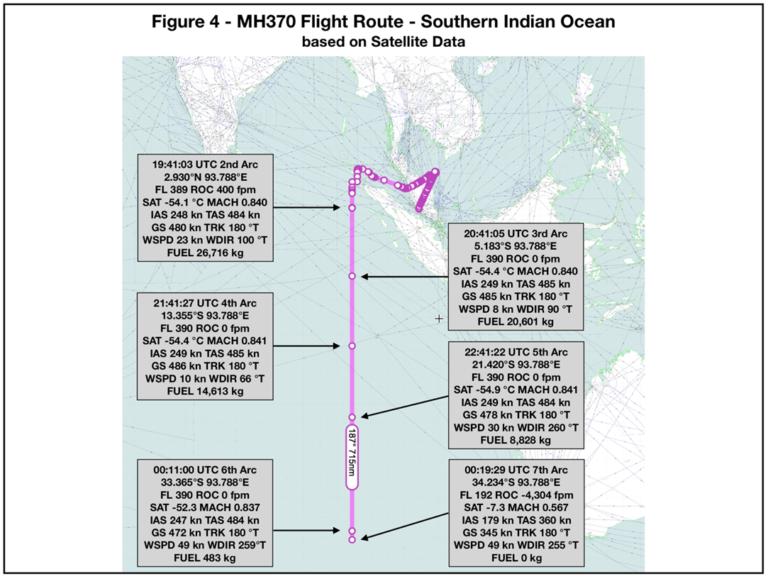
The calculations initially produced two possible corridors. One extended north through Asia, while the other extended south into the Indian Ocean. When radar coverage, aircraft performance, fuel endurance and other information were considered, the northern corridor was gradually ruled out. The remaining evidence pointed towards a long flight south into the remote southern Indian Ocean.
The last complete satellite handshake took place at about 0811. At approximately 0819, the aircraft’s satellite unit made another log on request. Investigators believed that this may have happened after electrical power to the system was interrupted and then restored, possibly when the engines stopped after the aircraft ran out of fuel.
A final incomplete satellite transmission was recorded shortly afterwards. Nothing more was heard from MH370. From the available evidence, investigators believed that the aircraft had ended its flight somewhere near what became known as the seventh arc in the southern Indian Ocean.
The Search Moves to the Southern Indian Ocean
On 24 March 2014, the Malaysian Prime Minister announced that the satellite information indicated that MH370 had ended its flight in the southern Indian Ocean. The search then moved to one of the most remote and difficult parts of the world.
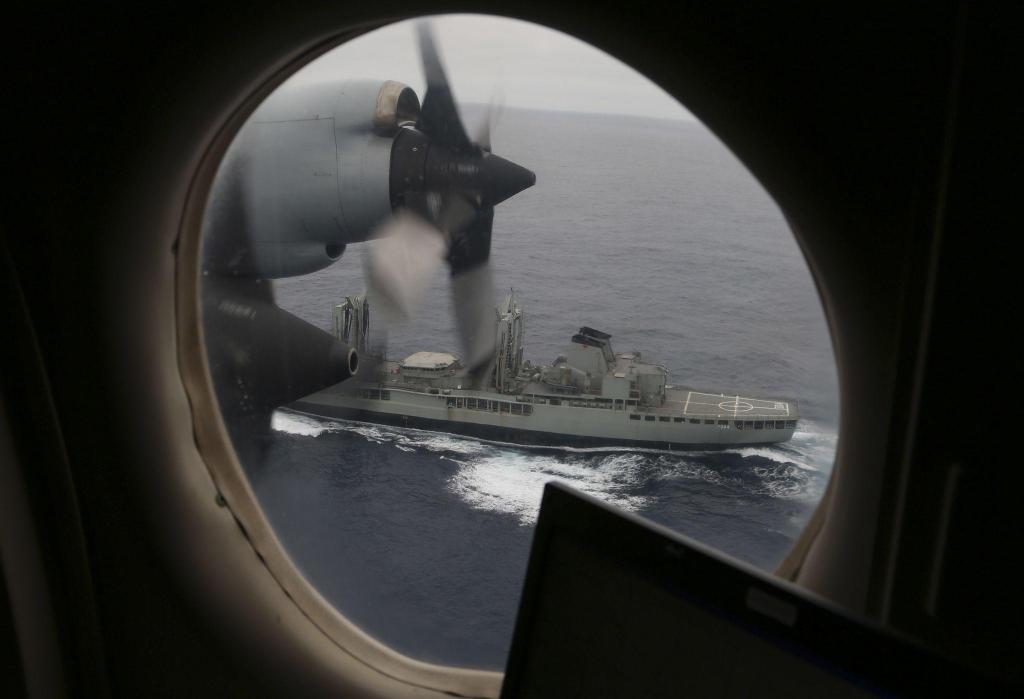
Search aircraft began flying long missions from Western Australia. Naval and civilian ships also searched large areas of ocean for anything that might have come from the aircraft. The search area changed several times as experts continued studying the satellite information, possible aircraft speeds, fuel consumption, winds and ocean currents.
In early April 2014, several underwater acoustic signals were detected. There was hope that they might be coming from the underwater locator beacons attached to the flight data recorder and cockpit voice recorder.
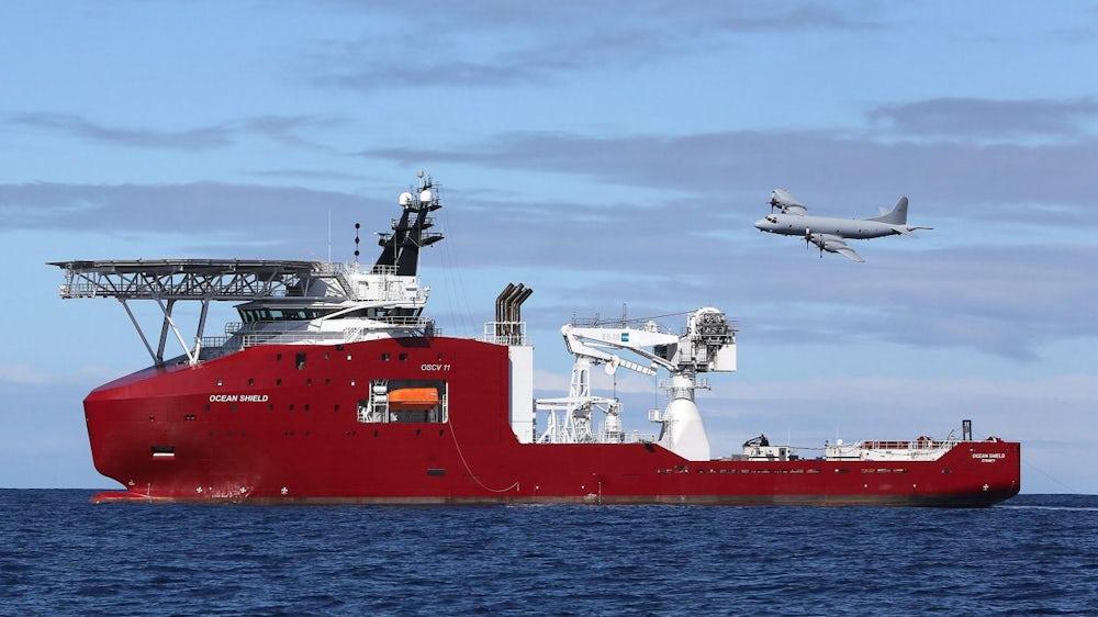
The Australian vessel Ocean Shield used a towed pinger locator to listen for the signals. A Bluefin 21 autonomous underwater vehicle was later sent down to search the seabed near the area where the signals had been detected.
The Bluefin 21 searched approximately 314 square kilometres of seabed, but it did not find MH370. Further examination of the acoustic signals showed that they were unlikely to have come from the aircraft’s recorders.
Before a much larger underwater search could begin, the seabed had to be properly mapped. Much of the area was several kilometres deep and contained steep ridges, deep valleys and underwater mountains. Search equipment had to be taken close to the seabed to obtain clear sonar images, but it also had to be kept far enough away to avoid being damaged.
From October 2014, vessels including ‘Fugro Discovery’, ‘Fugro Equator’ and ‘GO Phoenix’ began the main underwater search. They used sophisticated sonar equipment to scan the seabed. Autonomous underwater vehicles were also used in places where the terrain was too difficult for equipment being towed behind a ship.
Australia, Malaysia and China jointly supported the operation, while the Australian Transport Safety Bureau led the underwater search. By January 2017, more than 120,000 square kilometres of seabed had been examined.
The sonar images produced 661 areas of interest. The most promising of these were studied more closely, but none turned out to be MH370. Four previously unknown shipwrecks were found, showing that the equipment could identify objects on the seabed, but the missing Boeing 777 was not among them.
The First Piece of MH370 Is Found
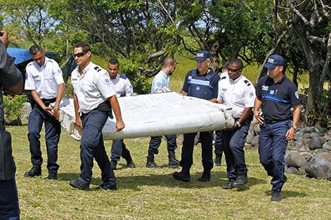
On 29 July 2015, more than sixteen months after the aircraft disappeared, a large piece of aircraft wreckage was found on Reunion Island in the western Indian Ocean. It was identified as a right wing flaperon from a Boeing 777 and was later confirmed as belonging to MH370.
This was the first physical proof that MH370 had ended up in the Indian Ocean. It also showed how far aircraft wreckage could travel after being carried for many months by ocean currents and winds.
Other pieces were later found in Mozambique, Tanzania, South Africa, Madagascar, Mauritius and other locations around the western Indian Ocean. Some were confirmed as coming from MH370. Others were assessed as almost certain, highly likely or likely to have come from the aircraft.
Investigators examined identification numbers, manufacturing records, paint, damage and marine growth on the recovered pieces. Ocean drift experts also studied how the wreckage might have moved from the suspected accident area to the places where it was found.
The wreckage supported the belief that MH370 had ended its flight in the Indian Ocean, but it did not show exactly where the aircraft had gone down. No bodies, engines, main fuselage sections or flight recorders were recovered.
The First Major Search Ends Without Finding the Aircraft
On 17 January 2017, Malaysia, Australia and China suspended the official underwater search. This did not mean that investigators no longer believed that MH370 was in the southern Indian Ocean. It meant that the selected search area had been covered without locating the aircraft.
A later review by international experts concluded that the most likely position might be farther north along the seventh arc. They identified another area of approximately 25,000 square kilometres that they believed should be searched.
The studies of ocean currents and the movement of the recovered wreckage also helped experts to reconsider the likely accident position. However, without finding the main wreckage, every calculation still contained some uncertainty.
The Australian Transport Safety Bureau described the disappearance of a large modern passenger aircraft with 239 people on board as almost inconceivable and socially unacceptable in the modern aviation age. Yet, despite years of work and the use of advanced technology, investigators still could not say exactly where the aircraft was or what had happened inside it.
Ocean Infinity Joins the Search
In January 2018, the private seabed exploration company Ocean Infinity began another search. It entered into a ‘no find, no fee’ agreement with the Malaysian Government, meaning that it would be paid only if the aircraft was found.
Ocean Infinity used the vessel ‘Seabed Constructor’ and several autonomous underwater vehicles. These vehicles could work independently and search different sections of the seabed at the same time. They could also operate at depths of up to approximately 6,000 metres.
By the time this search ended in June 2018, Ocean Infinity had examined approximately 112,000 square kilometres of seabed. The company covered the priority area and also searched other possible locations, but MH370 was still not found.
What the Official Investigation Found
Malaysia’s official safety investigation report was issued in July 2018. It examined the aircraft, crew, passengers, cargo, maintenance records, communications, radar information, satellite data and the search operation.
The investigators considered several possibilities, including a fire, loss of cabin pressure, mechanical failure, hijacking, crew action and unlawful interference. However, they did not find enough evidence to prove any one of these possibilities.
The aircraft had a valid certificate of airworthiness and had been properly maintained. Investigators did not find a known defect that could explain the disappearance. There was also no distress call or message reporting a serious technical problem.
The investigation concluded that the change in the aircraft’s flight path probably resulted from manual inputs. It also stated that the possibility of intervention by a third party could not be ruled out. However, it could not establish who was responsible for changing the flight path or why it was done.
Many theories have been put forward over the years. They include pilot action, hijacking, fire, loss of cabin pressure and military involvement. There have also been many other claims that have little or no reliable evidence behind them.
As investigators, we must be careful not to mix up what we know with what we merely think may have happened. Without the main wreckage and flight recorders, nobody can honestly say that the mystery has been solved.
What the People of Kudahuvadhoo Island in Maldives Saw
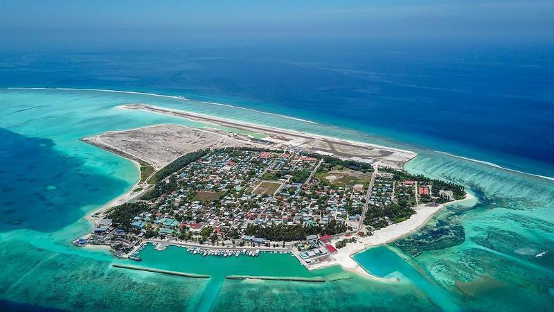
The Maldives became connected to the MH370 story because of what several people from Dhaalu Atoll Kudahuvadhoo Island said they saw early in the morning of 8 March 2014. At about 0615, they saw a very large aircraft flying unusually low near the island.
Malaysia is three hours ahead of the Maldives. This means the sighting happened on the same morning that MH370 disappeared, several hours after it had left Kuala Lumpur.
The witnesses said the aircraft was much larger and lower than the aircraft they normally saw near Kudahuvadhoo. Some said it was white with red markings. They also remembered the unusually loud noise it made.
They said the aircraft flew from the north towards the southeast, in the direction of southern Maldives. Some said it was so low that they could see its windows and doors. Fishermen and others who were awake that morning said its noise was very different from aircraft normally flying high above the island.
More than twenty people later said they had seen or heard the aircraft. In 2015, Maldivian police interviewed 21 people from Kudahuvadhoo about what they saw that morning.
Some people brushed aside their story as hogwash. They said there was no radar evidence of MH370 entering Maldivian airspace. The Inmarsat satellite calculations also placed MH370 much farther southeast in the southern Indian Ocean.
It was also suggested that the people might have seen another aircraft. This is possible because honest witnesses can still be mistaken about an aircraft’s type, size, height, direction or the exact time it passed.
However, something that happened during an aircraft accident investigation course I attended in Canberra has always remained in my mind. During the course, I visited the Australian Transport Safety Bureau’s investigation laboratory. Some pieces of debris confirmed as coming from MH370 were being kept there.
During that visit, I spoke about the Kudahuvadhoo sighting with the person who was then the Chief Commissioner of the ATSB. After hearing about what the islanders had said, he asked me a very simple question, ‘Why would they lie?’
This did not mean that the ATSB had concluded that the aircraft was MH370. It was not an official finding. It was simply a question the Chief Commissioner put to me during our discussion.
However, it was a fair question. These were ordinary island people with no known reason to make up such a story. They may not have known what type of aircraft they saw, but they knew that it was very large, unusually low and extremely noisy.
Their statements should have been properly recorded and compared. They should also have been checked against every known aircraft movement in the area that morning.
I am not saying that the people of Kudahuvadhoo definitely saw MH370 because there is not enough evidence to prove that. At the same time, their story should not be laughed at or dismissed simply because it does not fit the main search theory.
The people of Kudahuvadhoo saw and heard something very unusual that morning. Even after all these years, the aircraft they described has not been properly identified. The question put to me at the ATSB laboratory, ‘Why would they lie?’, therefore remains unanswered.
The Work Continued Even When the Ships Stopped
The work on MH370 did not end when the ships left the search area. Experts continued studying the satellite signals, aircraft performance, fuel endurance, possible descent rates, ocean currents and pieces of wreckage.
Marine biologists examined barnacles and other marine growth found on the recovered parts. They tried to determine where the pieces might have travelled and how long they had been in different water conditions.
Experts also studied acoustic recordings, satellite images and information recovered from the aircraft captain’s home flight simulator. Independent researchers proposed different possible accident positions using satellite data, ocean drift and other methods.
Some of this work has helped improve the understanding of the aircraft’s possible final flight. However, none of the proposed methods or positions has so far led searchers to the aircraft.
The Latest Ocean Infinity Search
After several years without another underwater operation, Ocean Infinity proposed searching a new area of approximately 15,000 square kilometres in the southern Indian Ocean. The Malaysian Government accepted the proposal under another ‘no find, no fee’ arrangement.
Under the agreement, Ocean Infinity will receive US$70 million only if the wreckage is found. The formal agreement was signed on 25 March 2025.
Search work under the agreement was carried out from 25 to 28 March 2025. The operation later continued from 31 December 2025 until 23 January 2026.
Altogether, 28 operational search days were completed after the agreement was signed. Approximately 7,571 square kilometres of the selected seabed area were surveyed. Ocean Infinity also carried out some search work before the agreement was formally signed.
The operation was repeatedly affected by difficult weather and sea conditions. By March 2026, the latest search had not found anything that confirmed the location of MH370.
The Search Has Not Ended
On 26 June 2026, the Malaysian Cabinet agreed to extend its agreement with Ocean Infinity for another twelve months. The extension runs from 1 July 2026 until 30 June 2027.
The same no find, no fee arrangement remains in place. Ocean Infinity will be paid only if it successfully locates the wreckage.
There are still 7,428.54 square kilometres of the agreed search area to be completed. Ocean Infinity’s main equipment has temporarily been sent for other commercial work. The company is expected to return between November 2026 and April 2027, when the sea conditions in the search area should be more suitable.
Therefore, as of July 2026, the search for MH370 is not over. The aircraft has not been found, but there is still another opportunity to search the remaining area.
The World Is Still Waiting
More than twelve years have passed since MH370 left Kuala Lumpur. Children have grown up without their parents, parents have grown older waiting for their children, and many families have been unable to say a final goodbye.
The disappearance also exposed weaknesses in aircraft tracking, communication between air traffic control centres and the handling of an aircraft that goes missing while moving from one area of responsibility to another. Aviation has made improvements since then, but the main questions about MH370 remain unanswered.
We still do not know who changed the aircraft’s course. We do not know why its communication systems stopped operating, what happened to the passengers and crew or exactly where the aircraft entered the ocean.
For my Malaysian friend, the person he dearly loved is not simply one of 239 names on a passenger list. The same applies to every family and friend who lost someone on MH370. Each person on board had a life, a family and people waiting for them to come home.
Finding the aircraft may not immediately answer every question. After so many years under the sea, nobody knows whether useful information can still be recovered from the flight recorders. Nevertheless, the wreckage itself could show how the aircraft entered the water, whether it broke up before or during impact and what position some of its controls and systems were in.
The people of Kudahuvadhoo also remain part of the story. Nobody has proved that they saw MH370, but nobody has satisfactorily explained what so many of them saw and heard that morning either. Their account should be treated fairly and kept separate from claims that cannot be supported by evidence.
The world is still waiting for answers, but above all, the families are waiting. Hopefully, when Ocean Infinity returns to the southern Indian Ocean and completes the remaining search area, MH370 will finally be found. It may not answer every question, but it could at least help us understand what happened to the aircraft and the 239 people who disappeared with it.
 Ibrahim Khalid
Leave a comment